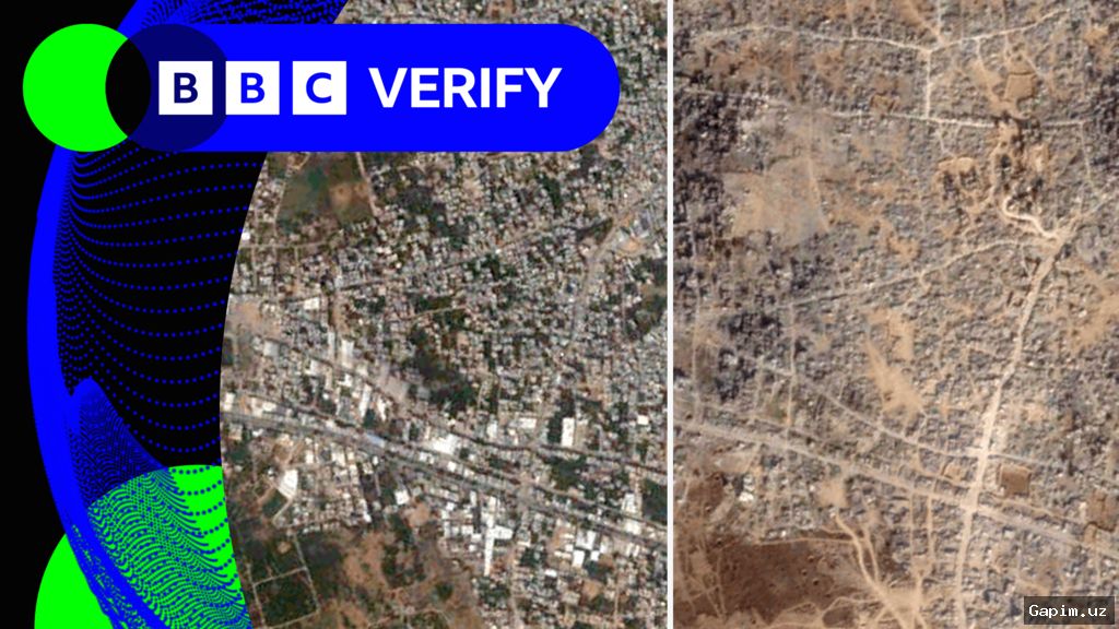
Palestinian journalist Muhannad Qishta yearns to visit the graves of his sisters – Reem and Walaa – in Khan Younis in southern Gaza, but there is a problem: they no longer exist on a map. Updated satellite imagery on Google Earth shows the Sheikh Mohammed cemetery in the Maan area of Khan Younis has been wiped from the map and replaced by an Israeli military outpost.
“Even the dead have not been spared from this war,” Qishta told Al Jazeera. “How will I feel if I go and find the place a desert, without my sisters’ graves to read a prayer over?”
The high-resolution pictures, captured on February 25, 2026, expose a landscape where entire neighborhoods have been reduced to ash, and the surviving population is squeezed into suffocating encampments that spill onto the beaches of the Mediterranean Sea. For Palestinians, the updated maps provide a devastating, wide-angle view of an ongoing genocide that has killed nearly 73,000 people.
According to the Euro-Med Human Rights Monitor, Israeli forces have fully or partially destroyed 94 percent of Gaza’s cemeteries, transforming places of memory into military barracks. The satellite imagery confirms that major residential centers have vanished, altering the geography of the Strip beyond recognition.
In Rafah, the crushing scale of destruction has rendered neighborhoods indistinguishable from others. The Saudi neighborhood in Tal as-Sultan – a sprawling 752-unit housing project – has been flattened into vast mounds of rubble. US President Joe Biden initially drew a ‘red line’ over the invasion of Rafah in early 2024, but Israel went ahead with its brutal operation without facing consequences.
The Swedish village in Rafah has been systematically wiped from the map, transformed from a vibrant coastal community into a military zone. Founded in 1965 with international assistance to shelter Palestinian refugees, the village now hosts only five remaining houses. The Rafah border crossing, once the sole lifeline to the outside world, has been gutted and replaced by fortified Israeli observation posts.
Straight through the eastern neighborhoods of Bani Suhaila, Abasan and al-Zana, tanks are embedded among civilian homes. Before the war, these districts housed nearly 120,000 residents. Following intense bombardment and systematic demolition, most of the population was forcefully displaced to overcrowded tent camps in al-Mawasi or shelters in Deir el-Balah.
Hamad City in Khan Younis – a $135m residential complex built with Qatari funding – is now a ruined shell. UNICEF says more than 97 percent of schools have been damaged or destroyed, leaving 658,000 children without formal learning for over two years. The Islamic University of Gaza (IUG) and Al-Azhar University have been razed.
The agricultural lands of Rafah and Khan Younis, once Gaza's food basket, are largely destroyed. The UN Food and Agriculture Organization (FAO) reports that less than five percent of Gaza’s agricultural land remains usable. In the Shakoush area, Israeli bulldozers have razed greenhouses and confiscated topsoil.
With 1.9 million of 2.3 million Palestinians internally displaced and 60 percent having lost their homes, families are forced into an ever-shrinking perimeter. Satellite images show extreme density in al-Mawasi displacement camps. Israeli Prime Minister Benjamin Netanyahu has stated that Israel controls 60 percent of Gaza and ordered expansion to 70 percent.
Despite a US-brokered “ceasefire” in October, Israel continues military operations. An Al Jazeera tally recorded at least 2,400 Israeli violations between October and April. Palestinian journalist Ola Abu Moamer noted: “Satellites photograph the destroyed buildings, but they cannot document the feeling of a human searching for their home to no avail.”
Source: www.aljazeera.com