The ongoing El Nino weather phenomenon could become the most powerful since records began 40 years ago, the United Nations has warned. In an update released Thursday, the World Meteorological Organization (WMO) said the event is set to intensify and will almost certainly persist until February next year.
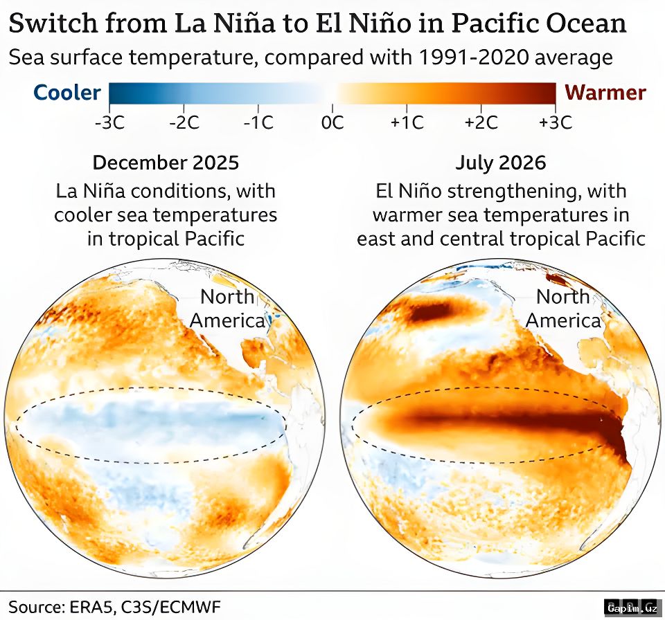
The UN weather agency cautioned that El Nino will likely develop into a 'very strong' event in the coming months, heightening risks of extreme heat, drought, and flooding while threatening livelihoods and economies across the globe.
UN Secretary-General Antonio Guterres stated, 'El Nino is being supersized before our eyes. The science leaves no room for doubt: the planet is in uncharted waters, and those waters are heating up.' His remarks underscore growing concerns among scientists and policymakers about the accelerating impacts of climate change.
WMO Secretary-General Celeste Saulo told a press conference in Geneva that, based on current trajectories, this El Nino 'may be stronger than anything since our monitoring began, so literally off the charts we have used for the past four decades.' She emphasized the unprecedented nature of the event.
El Nino is a natural climate phenomenon that recurs every two to seven years and is not directly caused by climate change. However, scientists point out that it can exacerbate the effects of global warming driven by continued fossil fuel combustion, leading to more severe weather extremes.
The WMO classifies El Nino events as weak, moderate, strong, or very strong, with the current event expected to reach the highest intensity level. The phenomenon begins with warming of sea surface temperatures in the central and eastern equatorial Pacific, triggering shifts in wind patterns, atmospheric pressure, and rainfall distribution worldwide.
Typical impacts include dry conditions and drought in Australia, Indonesia, and parts of the Amazon, while East Africa and the southern United States may experience heavy rainfall. El Nino events usually start between March and June, peak toward the end of the year, and last nine to twelve months.
Saulo reported an 'exceptionally high likelihood of nearly 100% that El Nino will persist through to February 2027,' marking the first time the organization has expressed such a high degree of certainty. Sea surface temperatures in the tropical Pacific, which drive the phenomenon and reshape weather patterns thousands of kilometers away, are already well above average and continuing to rise.
Subsurface ocean temperatures are also exceptionally high, with some areas recording more than 8 degrees Celsius above normal during July and early August, according to Saulo. While El Nino is expected to peak toward the end of the year, its knock-on effects will likely last well into 2027.
Global average temperatures often spike in the year following an El Nino. The 2023-2024 El Nino, for instance, contributed to 2024 being the warmest year on record. Saulo warned, 'We should not be surprised if this record is broken,' highlighting the potential for further temperature extremes.
Saulo stressed that droughts, floods, and extreme heat are already causing disruption and devastation, and these impacts will 'multiply and cascade as El Nino intensifies.' She called for urgent preparations to safeguard climate-sensitive sectors, stating, 'We have no time to lose.' The WMO's warning serves as a stark reminder of the growing urgency to address climate-related risks.
Source: www.dw.com